![]()
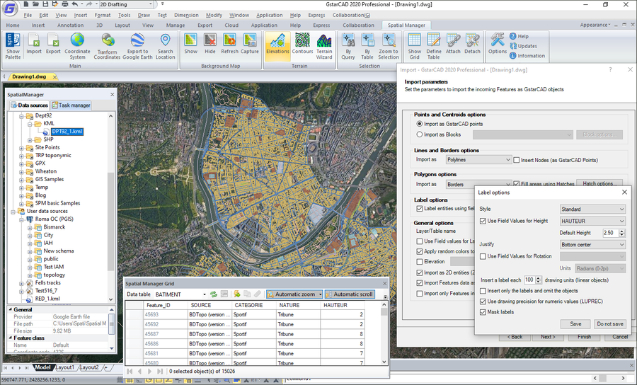
Jetzt können endlich auch GstarCAD-Anwender mit GIS Daten arbeiten! Spatial Manager für GstarCAD macht das Tor für vielfältige Daten-Importe und -Exporte auf, damit auch komplexes Kartenmaterial mit GstarCAD bearbeitet, analysiert oder transformiert werden kann.
Sehen Sie nachfolgend die umfangreiche Feature-Liste. Spatial-Manager Software steht in deutscher Sprache zur Verfügung:
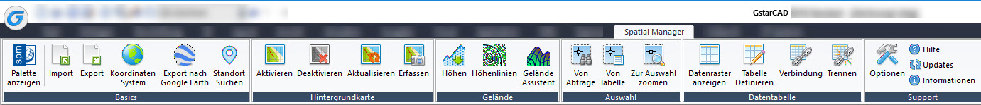
Importieren Sie Geodaten in GstarCAD
Importiert räumliche Daten in neue oder vorhandene GstarCAD-Zeichnungen als GstarCAD-Objekte und Erweiterte Entitätsdaten (EED)
Exportieren von Geo-Daten aus GstarCAD
Exportieren von Objekten aus der Zeichnung in Geo-Dateien oder Datenbanken und speichern ihrer Erweiterte Entitätsdaten (EED) als alphanumerische Datentabellen
Datenmanagement, Abfrage und Bearbeitung
Verwaltung von alphanumerischen Daten im Anhang von Objekten, Entwurf und Bearbeitung der Struktur, in der die Daten gespeichert werden
Umwandlung von Koordinaten
Berechnen der geometrischen Umwandlungen der Objekte in den Import- und Export-Prozessen
Hintergrundkarten
Wählen Sie aus einer Vielzahl dynamischer Hintergrundkarten von Anbietern wie OpenStreetMap, Bing, MapBox, Ordnance Survey usw. oder konfigurieren Sie Ihre eigenen Karten von TMS-, WMS- oder WMTS-Servern
Datenraster
Mit der Datenraster-Palette können Sie die Objektdaten in einer beliebigen Tabelle in der Zeichnung anzeigen, bearbeiten usw. Sie können auch Objekte aus dem Datenraster auswählen, Daten aus den Tabellen exportieren und vieles mehr
Standorte suchen
Suchen Sie in Ihrer Zeichnung Postadressen, Straßen, Nachbarschaften oder andere geografische Objekte
Gelände
Erstellen Sie Gelände und andere verwandte Objekte (3D-Punkte, Konturen usw.) aus 3D-Daten oder Höhendiensten
Veröffentlichung auf Google Earth
Exportieren Sie alle oder einen Teil der Objekte in den sichtbaren Ebenen der Zeichnung und ihre Daten in eine KML- oder KMZ-Datei
Aufgaben importieren
Speichern Sie Aufgaben, um Import-Prozesse (einschließlich aller Prozessparameter) so oft wie gewünscht erneut auszuführen
Mehrsprachen-Option
Verfügbar in Englisch, Deutsch, Spanisch, Französisch, Russisch und Portugiesisch
Unbefristete Lizenz
Einmal-Zahlung, keine regelmäßigen Gebühren
Notes:
- The access to spatial data servers and stores, the XDATA / Extended Entity Data (EED) and the Background Maps are available in the "Standard" and "Professional" editions only. The Data grid palette is available in the "Professional" edition only
- The complete Export capabilities are available in the "Professional" edition only, although "Export the current status of the drawing to Google Earth" is a function available in the "Standard" edition also
- The Tasks technology is available in the "Professional" edition only